|
|
|
|
|
|
|
|
|
|

|

|

|

|
Walks | From RussellRussell Village | Matauwhi Bay | Long Beach
Long Beach Walkway
View Larger
Map
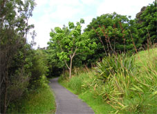
The Long Beach walkway is a paved off-road footpath from
the York Street/Wellington Street intersection to just
above the Long Beach waterfront.<
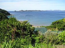
Long Beach is
a spectacularly beautiful and safe sandy swimming beach
looking north east towards the main islands of the Bay of
Islands with Cape Brett and the open entrance to the Bay
in the far distance.
The Long Beach Walkway is the easiest pedestrian route
from Russell town centre to the beach. Just beyond the
camping ground on Long Beach Road the walkway branches
left from the road and follows the valley floor through
replanted native trees before climbing gently to the
saddle of the hill beside the Russell cemetery and the
intersection with Queens View Road. It then follows the
road down the hill and ends above the north-western end
of the beach.
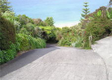
From that point you can either take the high tide track
to Waitata Bay or continue the short distance down the
roadway to Long Beach itself.
|
Location,
Grade and Duration
The walkway
can be accessed from Wellington Street at the north end
of Russell beach, The Strand, York, Church or Baker
streets. The grade is moderate and the walk takes about
10 minutes each way. That can be extended by exploring
Long Beach and Waitata Bay as desired.
There are
alternate routes to go or return and they all require
steeper climbs or descents. From Long Beach you can climb
the Oneroa Road paper road and then continue back down
Oneroa Road to the town. Behind the huge Morton Bay Fig
tree towards the north-western end of Long Beach is a
wide sealed access way and a short way up a path branches
and follows above it on the right continuing up the hill
and ending in another very steep driveway to join Oneroa
Road proper at the top of the hill where it intersects
with Queens View Road. This route is unsafe in slippery
wet conditions.
A less demanding ascent is via the Long Beach Walkway to
Queens View Road and then up that to Oneroa Road. Either
way, there are great views in both directions from the
top of that hill.
From the intersection of Oneroa Road and Gould Street you
can descend directly to the centre of town via the Zigzag
track or continue left along Gould Street and descend via
Hazard Street and the Hazard Street track finishing
beside the Fire Station on Baker Street or continuing
through to Church Street.
|
Restrictions
The Oneroa
Road paper road track is unsafe in slippery or wet
conditions, especially the steep driveways at the top and
bottom.
The Zigzag track is also reasonably strenuous and
requires moderate fitness.
Apart from the Long Beach walkway route there are no
footpaths on any of these roads so beware of traffic.
There is no footpath at the end of the Long Beach walkway
for about 50 metres down to the beach.
There are toilets at the north-western end of Long Beach.
|
Interests
At the bottom
of Wellington Street are some historic old houses and the
road then passes the Russell Top 10 Holiday Park. Just
before reaching four pensioner cottages on the left the
track diverges from the road to follow a wetland valley
filled with native plants and birdlife up to the
cemetery.
The
charitable Duffus Memorial Trust built the pensioner
cottages and Landcare Trust volunteers did the native
planting along the walkway.
The alternative route up Chapel Street passes the Shrine
of St Peter Chanel, built in 1960 replacing an earlier
Catholic church on the hillside which burned down in
1892. Bishop Pompallier had bought the land in 1841.
There is a small cemetery at the rear of the chapel. The
shrine is inside the chapel and was erected in the memory
of the Marist missionary who was martyred by natives in
1841. Zig-zag Track is a continuation of Chapel Street
but impassable for cars. Russell's
roads were planned in London ignorant of the steep
terrain.
The steep descents at the ends of Oneroa Road to Long
Beach and Brind Road to Matauwhi Bay also reduced to
walking tracks when the road plans reached Russell.
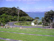
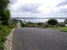
The historic Russell cemetery at the top of the hill has
lovely views in both directions and both old and new
graves. The descent to Long Beach enjoys a wide vista of
the Bay of Islands.
|
History
Russell Top
Ten Holiday Park was the site of an army camp. During the
2nd World War terraces were cut into the hillside here.
An enemy invasion was anticipated to come from the north,
if indeed it did come.
Games of
rugby were fiercely fought here last century before the
holiday park grew trees on the field.
Long Beach
Road snakes its way up the side of a valley. This was the
route taken by the Waikare chief Kapotai when he came to
support Hone Heke at the time the flagstaff was felled in
1845. The original road was on the other side of the
valley, and was built by prisoners from
Russell's jail.
Queen's View Road takes its name from
1963 when Queen Elizabeth II visited Russell and was
driven to its junction with Oneroa Road to admire the
spectacular view. A seat was placed here in her honour,
so that others could stop to rest and enjoy the views
over the south-eastern Bay of Islands.
|
Walks | From RussellRussell Village | Matauwhi Bay | Long Beach
|
|

|
|

|
|
|
|
|
|
|


